Derive better subsurface insights regardless of data quantity
Many of today’s most prolific wells were previously considered economically or technologically unviable. As wells become increasingly complex and the energy industry continues to push the boundaries of exploration and production innovation, E&P companies must achieve exceptional levels of operational efficiency and productivity to be successful. Operating in these challenging environments requires a deep understanding of reservoir properties, drilling risk, environmental factors, financial impact, and more.
 Subsurface mapping can be useful for better defining assets, but it often involves multiple types of data analyzed by massive, high-science software. In a perfect scenario, an operator would map assets using a wide breadth of downhole data to reduce uncertainty, mitigate risk and enhance decision making. But in the real world, this data is often disparate, scarce, or unavailable. However, with the right workflow, even operators with limited data availability can increase confidence in their model and improve understanding of their subsurface assets.
Improve confidence and efficiency with intelligent, intuitive workflows
Full-scale earth modeling can be a complex, costly, and time-intensive investment. To make the most of your data, it’s crucial to find fit-for-purpose earth modeling workflows that are specific to your data and align to meet your needs. For many operators, mapping the subsurface and creating an accurate earth model can be challenging due to time and data constraints. The cloud-enabled DELFI cognitive E&P environment enables geoscientists to build accurate models in a wide range of conditions—from scenarios with basic well data to scenarios with a wealth of reservoir information, including seismic data.
- Scenario 1: Integrating seismic and well logs based on well tops
In today’s landscape, many operators face the challenge of having limited access to well data. Even with just well logs and tops available, users can leverage the DELFI cognitive E&P environment to create an accurate subsurface mapping that improves understanding of your asset’s structure and bulk rock volume, increasing the chance of drilling success.
- Scenario 2: Geologic models using your well logs
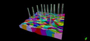
Even a simple gridding process can enable users to create 3D geocellular models that incorporate structured surfaces, log analysis, and property distribution without requiring significant time or capital investment. These valuable insights can be used to further study areas of interest and aid in well planning.
- Scenario 3: Integrating seismic and well logs for modeling
In most cases, an integrated approach using both well data and seismic data—be it 2D or 3D—helps provide greater insights into the structure, stratigraphy, and extent of your reservoir. This results in improved subsurface understanding, enabling you to identify potential geohazards and make more informed drilling decisions.
Learn how to build efficient, accurate models using your existing data. Watch how to run three different scenarios so you can map your subsurface assets and better interpret your reservoirs. Turn limited information into better decisions, faster.


